NEW ZEALAND TO FIJI
After last cruising season in Fiji (May to November) and our forced migration to New Zealand to repair hull damage (a reef scratched our bottom!), we were planning on spending another season lazing around the coasts of Vanua Levu (Fiji’s North Island), diving the splendid reef of the Somosomo Straight. But Winston changed all that.
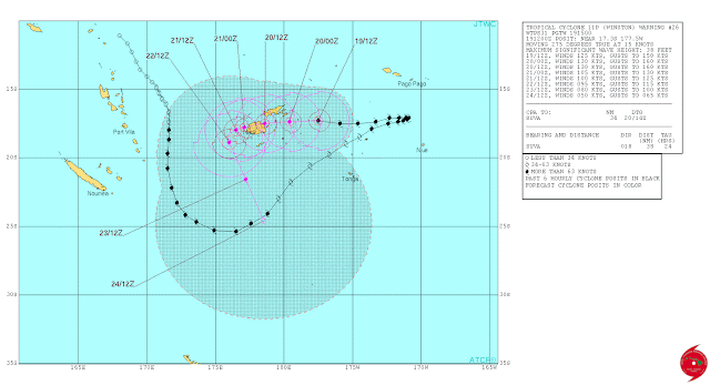
On February 20th, Cyclone Winston—A Cat. 5 Cyclone, the strongest cyclone to hit the South Pacific on record — slammed into Fiji. After skirting Fiji as a Cat. 2 cyclone, Winston travelled east toward Tonga, then made a 180 degree turn and tracked back toward Fiji, gathering strength. It slammed into Vanua Balavu (Northern Lau Group), unleashing winds at 165 mph and even a recorded gust at 190 miles/hour (306 km/h) and created a 30-foot (10 meter) surge that swamped roads, homes, schools, entire villages.
 |
| An amazing track: Winston travelled SSE, then NE, then tracked back full West... |
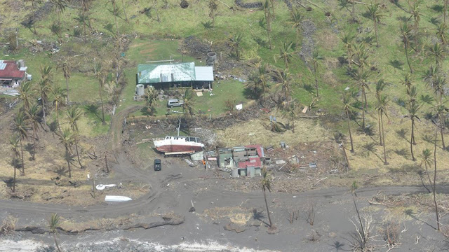
Winston continued its track west at 25 Kts, roaring over Taveuni and slamming into Savu Savu with sustained winds recorded at 145 mph (230 km/h.) Of the 52 boats in Savu Savu harbor, only 7 remained at anchor or on their moorings. All others were either washed ashore (some washed up 200 yards inland) or sunk. Our friends on Kaija’s Song lived to tell the horror of that night. Thanks to rapid help, Savu Savu is recovering; so is the mainland of Vanua Levu. Taveuni, accessible through its air strip, is also receiving help.
 |
| In Savu Savu, utter destruction! |
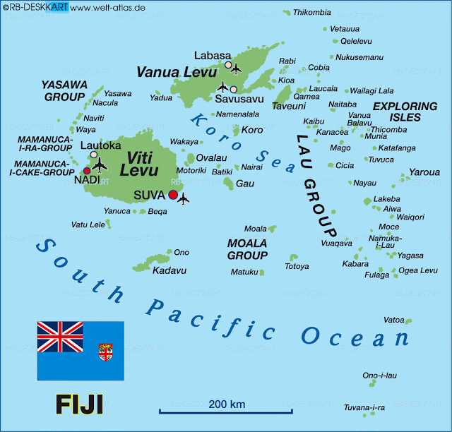
But what of the Northern Laus and Vanua Balavu? Isolated, absolutely devastated, Vanua Balavu and its surrounding islands are a long way from recovery. Some islands have not had any damage assessment yet.
 |
| The Lau Group, especially the islands in the north, Vanua Balavu and its surrounding isles were hardest hit |
We wanted to do something for the Fijians in the Northern Laus, who have welcomed us so warmly last season. But how to help? In comes SEA MERCY, a 4-year old relief organization made of volunteer cruisers. Strong of their experience in Vanuatu last year (Cyclone PAM devastated some areas of Vanuatu,) SEA MERCY is organizing a fleet of boats to spread all around Fiji and bring help to isolated villages. Our particular group, DR2A (Disaster Recovery Group 2A) is awaiting a weather window to head straight for Vanua Balavu where Sea Mercy has organized an exceptional clearance from the customs and immigration officials, though VB is not a normal port of entry.
| In Vulaga (Southern Laus) exporting clams is a sustainable commerce |
Several more groups have formed in Opua (New Zealand) and will leave either for Denarau (South Island of Viti Levu) or Savu Savu (North Island of Vanua Levu), while other vessels will arrive from other points (Australia, French Polynesia) and join the Sea Mercy fleet for the season. In all, some 40 yachts are involved in this massive recovery effort.
| Weather GRIB on Predic Wind |
While we are waiting for the large stationary high pressure system currently hovering over New Zealand to dissipate, and for weather window to open (looks like a May 11th departure), we are getting the boat’s communications ready, gathering waypoints and alternate routes with a stop-over at Minerva Reef.
COMMUNICATIONS
 |
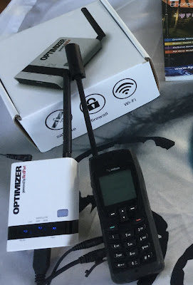
| Our new setup: Iridium 5555 + Optimizer |
- IRIDIUM + OPTIMIZER - The latest toy from Iridium is the IRIDIUM GO, a satellite WiFi hotspot with integrated GPS. But since our IRIDIUM 9555 handset is in excellent working order, we were not on the market for a new satphone. Enter the OPTIMIZER by RedPort, a little gizmo that plugs into the IRIDIUM handset and turns it into a WiFi hotspot. It comes with the X-Gate mail program and works seamlessly with our iPads and Macs.
 |
| PHYSPLOT: Our old set up: still valuable information, still will use it |
- Why would we want this anyways? Isn’t our old system of Windows-based weather GRIBs and Physplot Fleet Code plotting enough? Could be, and we are definitely keeping that option as backup.
For the last 2 years, while on passages, our daily mail (using X-Gate Mail) requests to saildocs under this setup have been- (and this is our back-up option now)
subject: (blank)
body: send fleet.nadi
send gfs:10S,40S,165E,165W|2,2|24,48,72,96|
( * more saildocs GRIBS available at gribinfo@saildocs.com
* for a list of saildocs documents available, send an email
subject: (blank)
body: send index
The robot responds within seconds and we drag the “Fleet NADI” email onto the Physplot program (more on the Pangolin Website) to see the current pressure chart for the South Pacific.
As for the “GRIB” email, all we have to do is open the attachment and it opens itself into the GFS reader.
A bit cumbersome, but it works well enough… now, for the new and improved and FASTER (saves minutes on the IRIDIUM plan)…
| Predict Wind Departure Planning.... doesn't look good right now... let's wait a few days! |
- PREDICT WIND - The new rage in passage weather routing, PREDICT WIND rocks! Fully integrated with the IRIDIUM GO (or IRIDIUM + OPTIMIZER) and the X-Gate Mail, Predict Wind offers offshore weather routing and GRIB files in quick download formats. Just prepare the email off-line using the Predict Wind Offshore App, fire-up the IRIDIUM hotspot, and BANG! in a matter of seconds you have your GRIB file, pressure map, and updated routing info. You can enter the parameters of your boats for maximum efficiency or comfort, and tweak your “POLARS” to your liking. Pretty nifty!
MET BOB - For years, we have subsribed to METBOB's weekly weather report. Once again, Bob McDavitt is helpful as he is analyzing the weather for our group's passage!
- Good old HAM Radio -
- PACIFIC SEAFARERS NET (14300 kHz @0300 UTC) - Still our favorite. The many operators and relays ensure the clearest possible communication with Americans. No weather info unless requested. Track our progress on the Pangolin YOTREPS
- GULF HARBOR RADIO (8752 kHz @ 1915 UTC) - David and Patricia run weather and roll call, a nice volunteer service. I’ve had difficulty understanding the Kiwi accent, however, and I’ve found the net to run longer than comfortable. Track us on the AIS tracker.
- SOUTH CROSS NET (8191 kHz @ 2000 UTC) - A small group of cruisers between NZ and Fiji share their positions and weather info.
- NORTHLAND RADIO (6227 kHz @ 0610 UTC) - Private Radio station in Russell
| OVITALMAP - Faster download, better resolution than SAS Planet and Open CPN/Google Amazing to watch your boat navigate into a harbor or through the reef! |
CHART PLOTTING - The apps for iPad and Mac keep popping up! Try OVITALMAP for iPad. The app uses the GPS location of your iPad to locate the boat on a satellite photo. You can choose either Google or Bing - Since we don’t have broadband Internet on passages, we cache images of all intended destinations before we leave home port. Unlike the SAS Planet or Open CPN programs that ask you to cache the downloaded images, OVITALMAP automatically saves all images as you explore the area. It’s lightning-fast! Zoom in, zoom out, it’s all saved! One caveat: check on the storage volume of you iPad!
| I love iSailor! so easy to share routes and tracks with other users! I can just take a photo or export to my Google Drive for all to use! TEST IF IT WORKS FOR YOU at My Drive.... |
For navigation, we still use the ship’s Navnet system (although it’s very inaccurate in the Lau Group), Navionics for iPad, and (my favorite) iSailor for iPad. Do we have enough info? Right! The danger is now that we spend too much time looking at the screens, not enough time looking out the window!!! BEWARE!!!
A note: The Island Cruising Association (Opua, NZ) has published an app to help cruisers with their Fiji travels, with some good weather planning info, some commonly travelled routes and waypoints, a cruising guide app worth a look.
CRUISING GUIDES - For Fiji, we have used Soggy Paws’ Compendium, and scores of blogs and notes gleaned from the Internet. There is precious little info on the Lau Group. For this reason, I will dedicate the next blog to the Laus, routes and waypoints.
| The Fijians have made us feel at home. We are ready to rebuild their homes! |
CONTRIBUTORS - I would be remiss if I didn't acknowledge the locals and internationals who are helping our Sea Mercy fleet. Particular thanks go to
- the Island Cruising Association for sharing their knowledge and meeting space.
- ITM for providing us with shelter building kits and solar lights
- BURNSCO for loading us with fiberglassing kits and fishing supplies
- METBOB for his weather routing
- METBOB for his weather routing
- The Satphone Store for helping us solve our communication issues
- The Wirie for keeping our WiriePro in good working order and updating its software
... and Jonathan on S/V Chez Nous, our tireless leader and coordinator!
... and Jonathan on S/V Chez Nous, our tireless leader and coordinator!
We are ready to go!
Until then…
dominomarie

